
Norley’s Diverse Habitats
Norley’s incredibly diverse wildlife is due to the diverse habitats found in the Parish. Possibly the most diverse places are its gardens and to some extent therein lies the greatest potential for increasing biodiversity.
Habitat mapping, Garden Surveys and the Wildlife map
In order to increase biodiversity, we need to map the parish and also enlist the help of Norleyans who can carry out surveys including their own gardens. Unless we have a clear idea of what habitats there are, and the wildlife they maintain, we will be unable to direct our resources and alert others to where the greatest benefits can be made, or where serious harm to wildlife is occurring. Establishing these benchmarks is a vital part of conservation.
Habitat Mapping – Overview
Studying our environment ensures we can protect Norley’s natural assets as part of our mission to help implement the biodiversity objectives in the Neighbourhood plan. Norley’s wildlife, as for the rest of the UK, is now highly fragmented and unable to respond to pressures such as climate change. Halting the loss of biodiversity requires sites for nature conservation to be ‘bigger, better and joined’. In order to achieve this, Core Sites, such as SSSI’s and Local Wildlife Sites, need to be linked together by Wildlife Corridors. Providing linkages will facilitate the movement of species from one site to another and allow declining wildlife populations to recover.
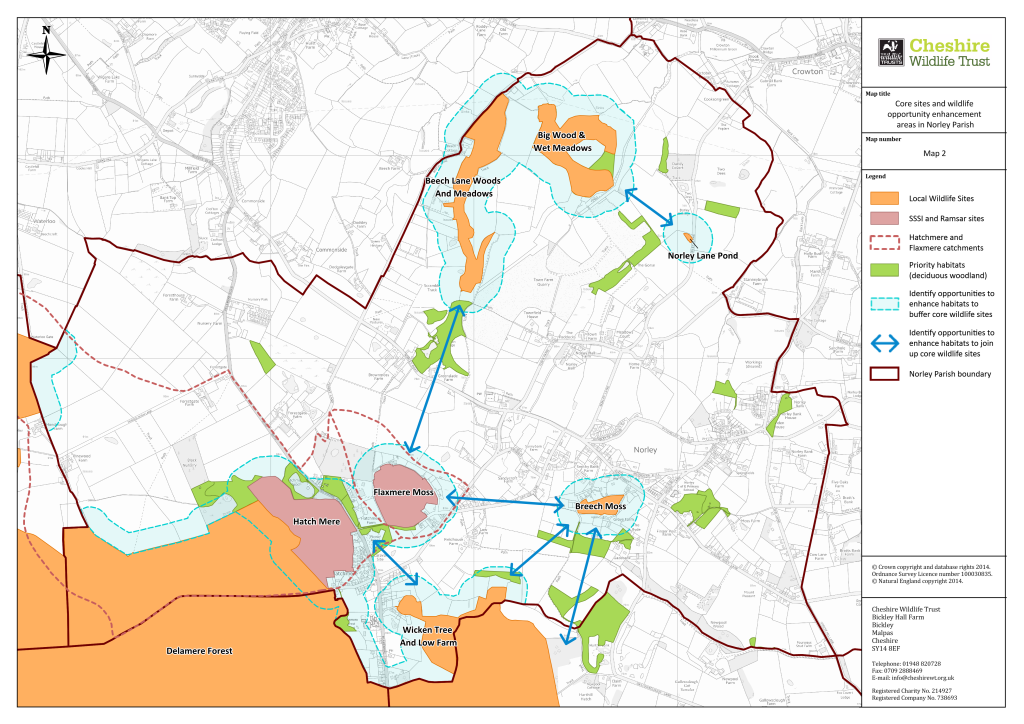 Core sites showing potential wildlife corridors
In 2016 we began working to create a detailed map of Norley’s natural habitats, the wildlife they support and how they link together. This has progressed so we now have a much better idea of what we have and what needs to be done to make it better. As part of this we have been identifying ancient trees, each of which can be a critical ecosystem in its own right.
One of these objectives is ‘to protect and enhance the natural environment and wildlife habitats in the area.’ In 2014, Cheshire Wildlife Trust (CWT) produced “Creating a Coherent Ecological Network for Norley” in which it sought to “identify, create, enhance, and maintain existing and new protected areas and associated buffer zones and wildlife corridors within the Parish in collaboration with landowners and other stakeholders in the Parish”.
You can download a full copy of the report in PDF format here.
Conservation focuses on animals, plants and the habitat in which they thrive. However, in order to conserve wildlife, we must know where it occurs and habitat mapping allows us to identify the distribution of species and habitats as well as the extent to which they are found.
Habitat mapping occurs over multiple phases. Phase 1 is a way of rapidly mapping wildlife habitats over large areas of countryside. These are usually based on overall vegetation and substrate within an area. Phase 2 looks into vegetation in more detail and defines plant communities living within it. Phase 3 looks into even finer detail identifying how many and where plant and animal species are distributed.
The NWG Habitat Mapping initiative will aim to provide a map of important habitats in Norley and conduct Phase 1 habitat surveys. The map and associated survey reports will form a baseline of knowledge about the habitats and wildlife in Norley against which future improvements can be identified and measured.

Phase 1 Surveys
The use of aerial photography and satellite imagery (e.g. Google, OS or Landcover maps) provides initial information on an area of land. In 2021 NWG did a series of walks in the parish using public footpaths. This provided ‘ground truthing’ of current habitats compared to those shown on a Landcover 2019/2020 map of the parish. The Landcover map was found to be broadly correct with minor changes between grassland and arable land.
In 2022 we commenced Phase 1 habitat surveys and this will continue over the next few years. In particular the surveys will be at sites designated by Cheshire Wildlife Trust as Local Wildlife Sites (LWS) and also sites within the connecting corridors between these LWS’s.
These sites include woodland, wet meadows, mosses and ponds, grassland, arable land, and hedgerows. Some habitats are best surveyed at different times of the year from others: woodland in Spring, grassland in mid-summer, open water mid-June to end September.
Any landowners, residents and other stakeholders who can assist by giving us permission to conduct a survey on their land particularly in the areas highlighted on the map, please contact us. We are also interested in any significant habitat improvement projects you may be involved in. We would very much welcome your involvement in our activities.
Latest News
Phase 1 habitat surveys were conducted at 6 sites in 2022 with landowners’ permission:
- Beech Lane Woods
- Sandybank Waste / Memorial Garden
- Brines Moss, Sandycroft Farm
- Pond, Norley Bank Farm
- Pond and Field Surrounding TownField House
- Newpool Wood and Battery Station.
In order to follow the wishes of some landowners and to safeguard vulnerable species, the Survey reports are only available to members of NWG and the landowners.
Habitat surveys at 16 sites were conducted in 2023 and reports are currently being prepared. Additional sites and landowner permission will be sought for 2024.
Wildlife Map – Overview
NWG has two pinboard maps of Norley which is used to collect information on wildlife sightings in the parish. One of the maps is now in use at Norley Church of England Primary School whilst the other is regularly used at the NWG stall at the Norley Garden Show in September.

Results of Garden Show Wildlife Survey 2023
Cheesehill Lane – Badger, Red Kite, Starling
Delamere Road – Kingfisher
Flaxmere – Smooth Newt
Guests Slack – Bats [Pipestrelles (common & soprano), Brown long-eared, Noctule], Badger, Buzzard, Hedgehog, Kestrel, Red Fox, Sparrowhawk, Spotted Woodpecker, Tawny Owl, Water Shrew
Hamblett’s Hollow – Cricket
Maddock’s Hill – Smooth Newt, Frog, Toad
Marsh Lane – Badger, Weasel
Moss Lane – Red Fox, Tawny Owl
Norley Lane – Grasshopper
Post Office Lane – Badger, Buzzard, Jay, Red Fox, Shrew, Small Owl, Vole
Pychley’s Hollow – Badger, Grasshopper
Sandhole Lane – Badger, Barn Owl, Bats, Buzzard, Canada Goose, Grasshopper, Kestrel, Red Fox, Tawny Owl
School Bank – Grasshopper, Pheasant, Spotted Woodpecker, Toad
GARDEN SURVEYS
Every year the RSPB and the Butterfly Conservation trust conduct national surveys which prove to be of great value in assessing how birds and butterflies are faring.
Similarly NWG has been collecting information on wildlife in Norley gardens. and a form is available in Norley news Residents are invited to join in our Spring and Autumn surveys to provide information on wildlife in their own gardens using the form issued in the Norley News or use our online survey by clicking this link https://www.surveymonkey.co.uk/r/FV8QDW3.
Information will be collated and posted in updates.